
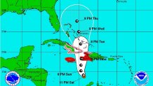
Hurricane Matthew remains a powerful Category 4 storm as it moves away from the Colombian coast and churns north through the Caribbean Sea. A 5 a.m. advisory from the National Hurricane Center said Matthew was moving north-northwest at 5 mph with maximum sustained winds of 150 mph. The storm will continue in this direction Sunday and reach Jamaica, Haiti and parts of Cuba by Monday, forecasters say.
Areas of southwestern Haiti and Jamaica will feel the effects of Matthew as early as late Sunday evening. A Hurricane Warning is in effect for Jamaica and portions of Haiti, from its southern border with the Dominican Republic to Le Mole St. Nicholas. Overnight, the government of Cuba also issued a Hurricane Warning for the provinces of Guantanamo, Santiago de Cuba, Holguin, Granma, and Las Tunas.
The government of the Bahamas, meanwhile, issued a Hurricane Watch for the Turks and Caicos Islands and the southeastern Bahamas, including the Inaguas, Mayaguana, Acklins, Crooked Island, and Long Cay.
Areas of Haiti can expect 15 to 25 inches of rain with isolated spots up to 40 inches. Jamaica, Dominican Republic and Cuba can expect 10 to 20 inches of rain with isolated spots 25 inches. This means life-threatening flash flooding and mud slides are possible.
The situation must continue to be monitored for areas of South Florida and elsewhere along the Eastern Seaboard as high amount of uncertainty remain in the forecast beyond day 3. The positive for South Florida comes in the shifting of the cone, although it is not completely in the clear. Hurricane force wind chances for Miami and Fort Lauderdale have been reduced to 2 percent and 3 percent, respectively.
The NHC says some fluctuations in intensity are possible this weekend, but Matthew is expected to remain a powerful hurricane through Monday. It's the strongest hurricane in the Atlantic since Felix in 2007.
