Storm surge occurs when ocean water gets pushed onto shore by a tropical storm or hurricane. County officials make evacuation decisions based on a hurricane's track and projected storm surge, so it's important to know which zone you live in before a storm hits.
Below is information for South Florida. Visit the state's Division of Emergency Management page for info on all Florida counties that have evacuation zones.
Stay up to date with NBC 6 First Alert Weather and South Florida's most powerful radar First Alert Doppler 6000 by downloading the NBC 6 app for iOS or Android.
Miami-Dade County
Get South Florida local news, weather forecasts and entertainment stories to your inbox. Sign up for NBC South Florida newsletters.
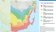
Miami-Dade County is split into five planning zones, marked A through E, that could each be affected by a storm surge of at least 1.5 feet. Find out which zone you're in by plugging in your address here.
- Zone A is at greatest risk for storm surge for Category 1 and higher storms
- Zone B is at risk for storm surge for Category 2 and higher storms
- Zone C is at risk for storm surge for Category 3 and higher storms
- Zone D is at risk for storm surge for Category 4 and higher storms
- Zone E is at risk for storm surge from Category 5 storms
Broward County
Broward County is split into two planning zones, A and B. Check out the county's evacuation map here.
- Zone A includes areas east of Intracoastal Waterway and is at greatest risk for storm surge for Category 1 and higher storms
- Zone B includes areas east of U.S. 1 (Federal Highway) and is at greatest risk for storm surge for for Category 3 and higher storms
HURRICANE SEASON 2021

Palm Beach County
Palm Beach County is split into six planning zones: A, B, C, D, E and L. Find out which zone you're in by plugging in your address here.
- Zone A includes those who live in a manufactured or mobile home, have substandard construction or live in a flood-prone area
- Zones B, C, D and E are along Palm Beach County's east coast
- Zone L runs along Lake Okeechobee
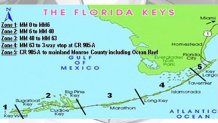
Monroe County
Monroe County is split into five planning zones, marked numerically. For more information on evacuating from the Keys, visit the county's website.
- Zone 1 runs from mile marker 0 to mile marker 6
- Zone 2 runs from mile marker 6 to mile marker 40
- Zone 3 runs from mile marker 40 to mile marker 63
- Zone 4 runs from mile marker 63 to the three-way stop at CR 905-A
- Zone 5 runs from CR 905-A to mainland Monroe County, including Ocean Reef