
Florida is in for a week of impactful weather regardless of how developing low pressure evolves north of the Greater Antilles.
That low, spurred by a deep dip in the jet stream, is not of pure tropical origin. But it has already caused flooding and damaging landslides in Puerto Rico, and even fatalities in the Dominican Republic when 9 inches of rain fell in just a few hours on Friday evening in the capital city of Santo Domingo.
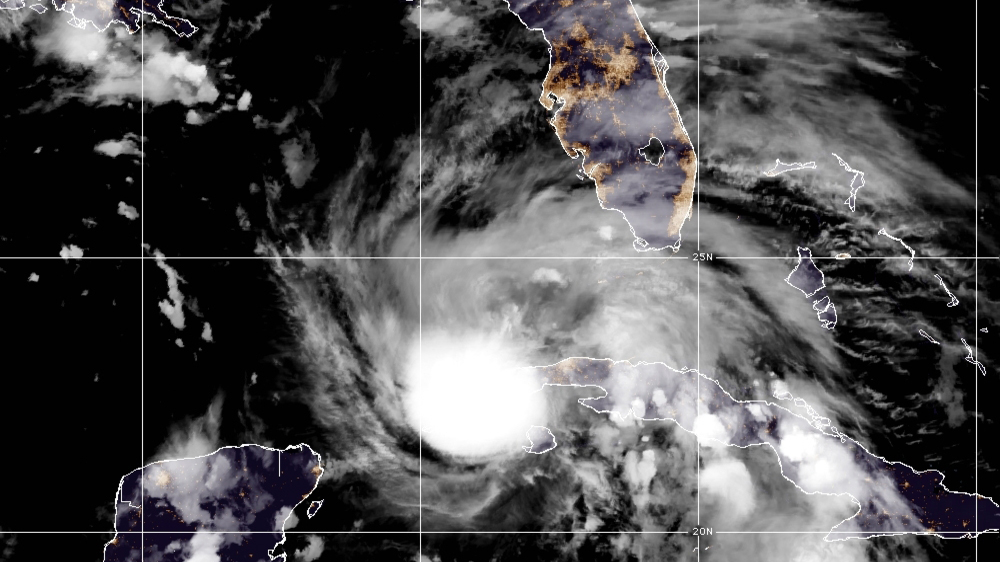
The National Hurricane Center will likely label the system as a Potential Tropical Cyclone, and both Broward and Miami-Dade could end up inside a “cone of concern” sooner than later.
While it’s likely that the low will, at worst, be a subtropical or tropical storm, there are one or two models that are forecasting a November hurricane for South Florida.
Get South Florida local news, weather forecasts and entertainment stories to your inbox. Sign up for NBC South Florida newsletters.
November is the last month of hurricane season and, typically, tropical activity starts to wind down. 2022’s Hurricane Season has been backloaded, however, and almost all of the impactful storms in the Atlantic this year formed after August.
The State of Florida has been hit nine times by tropical systems this month over the last 170+ years—about a 5 percent chance in any one year.
Seven of those nine came up from the western Caribbean and the Gulf of Mexico. That makes this week’s developing system, should it consolidate and hit Florida, quite rare.
But what’s exceptionally rare is for the Florida peninsula to get hit by a hurricane, regardless of where it originated, in the month of November.
There is only one hurricane on record that hit the peninsula in November, dating back to 1851—the so-called Yankee Hurricane which struck Miami Beach (near present-day Bal Harbour) on November 4th, 1935. It was a Category 2!
For now, the forecast calls for the frequency and intensity of rain showers to increase as we head into midweek. It will become increasingly windy, with hazardous marine conditions and a high risk of rip currents.
Winds and waves will combine with a full moon and sea level rise worsened by climate change to produce significant coastal flooding.
Communities such as Fort Lauderdale, Miami Beach, Miami Shores, and neighborhoods near Biscayne Boulevard including Edgewater, Coconut Grove, Coral Gables, and the Florida Keys, need to brace for potentially the worst saltwater inundation of the year.
The closest point of approach of the center of the system to Ft Lauderdale and Miami is expected to be Wednesday into early Thursday. But it is too soon to tell what form the system will eventually take—low pressure, a subtropical storm, tropical storm, or hurricane.
Obviously, no one wants to deal with a hurricane any time of year, much less now that holiday music is playing on the radio.
Decades ago, I might have been pretty dismissive of such a low-probability event. But I’m seeing way too many extreme weather events driven by global warming lately to discount yet another near-unprecedented event.
