
Ever since its formation late Wednesday, Tropical Storm Fiona has been hit incessantly by upper level wind shear. That means that westerly winds at the top of the storm are trying to put a cap on how tall the storm can stand while moving towards the Caribbean.
Since tropical storms can’t dance the limbo, it’s tough for them to get under the bar that’s being set lower by these west winds aloft. Now the question is, will Fiona fall?
After peaking at 60 miles per hour (mph) on Thursday, winds inside Fiona were down to 50 mph on Friday morning. It is an unhealthy tropical system, with its low-level center devoid of thunderstorms and exposed. Fiona’s center shows up as a swirl of clouds on satellite pictures.
Even though it should, it's hard to call for Fiona to weaken further given how the storm has already exceeded expectations.
Get South Florida local news, weather forecasts and entertainment stories to your inbox. Sign up for NBC South Florida newsletters.
The tropical disturbance from which it came from was surrounded by dry air on its north and west. And yet the dry air wasn’t able to prevent a tropical depression from forming. Then, as the depression moved westbound, the hostile wind shear increased.
Despite this, remote sensors on satellites detected winds of 50 mph on the northeast side of the circulation on Wednesday, so the National Hurricane Center (NHC) was forced to declare that the sixth named storm of the year had formed.
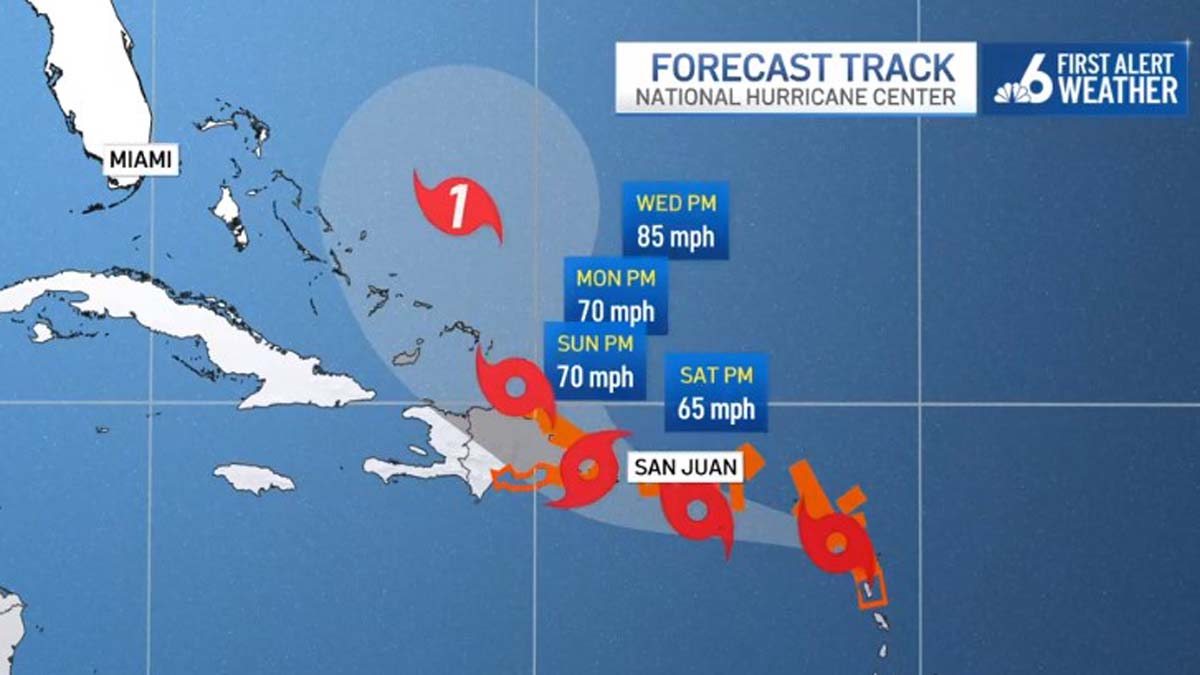
Tropical Storm Fiona

On Thursday night, though, those jabs of wind shear started to wear Fiona down. The strong westerlies aloft were forecast to continue Friday and Saturday as the system rolled past the Leeward Islands and then south of the Virgin Islands. This essentially guarantees that from Guadeloupe to Antigua, and beyond to Tortola and St. Thomas, it will be nothing more than a messy tropical storm.
Some model forecasts, however, show less impact from wind shear by Sunday. That’s the time the tropical storm would be moving past Puerto Rico at a distance of 65 miles from Ponce and 100 miles from San Juan, as per the Friday morning NHC forecast track. High pressure might develop over Tropical Storm Fiona to shield it from the detrimental wind shear.
If Fiona makes it in one piece to the waters south of the Mona Passage between Puerto Rico and the Dominican Republic, there’s a chance the storm could ramp up in intensity before potentially hitting Hispaniola late Sunday night into Monday. For now, the chance of hurricane force winds in Santo Domingo and Port-Au-Prince, Haiti stands at 2 and 1 percent, respectively.
For the Bahamas and Florida, the official NHC forecast has Fiona turning northwest and out to sea thanks to a change in steering currents beyond this weekend. On the NHC track, only the eastern Bahamas are in peril of having to tangle with Fiona’s core. But if Fiona remains weakened by the hostile conditions it is facing, then that track could extend further west.
Add to this the wildcard that the topography of Hispaniola brings. Mountains as tall as 10,000 feet could tear Fiona apart, depending on the track it takes and how healthy the storm is when it reaches that part of the Greater Antilles.
Given all this, Florida will need to keep tabs on Tropical Storm Fiona’s progress. A weaker storm that’s not discombobulated by island topography would be able to come closer to the Sunshine State next week.
For Miami and Fort Lauderdale, it still appears unlikely to impact us directly. But don’t tune out just yet.
