
Much of August has passed by with little traffic in the tropics. Yet in the final days of the month, multiple areas of interest are starting to pop up.
As of Saturday evening, the National Hurricane Center is identifying four areas for possible development over the next several days.
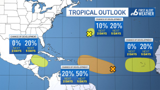
Of those, two hold some level of attention for South Florida.
The northwest Caribbean may be a safe area from some development in the week ahead, even with development chances at 20%.
Get South Florida local news, weather forecasts and entertainment stories to your inbox. Sign up for NBC South Florida newsletters.
While remaining removed from the region, it could enhance rain chances late in the week should it develop.
The most interesting feature lies in the central Atlantic, now with a 50% chance for development next week.
While short-term ebbs and flows of thunderstorm activity have been noted this weekend, no organization has taken shape.
Local


Over the last day or so, some computer model guidance suggests development in the coming days.
It’s far too soon to estimate the ultimate resolution, but it will be monitored accordingly just as any system at this point in the season.
Additional areas, adjacent to western coast of Africa and well east of Bermuda, stand a low chance for development and pose no threat to land at this time.
