
As has become the norm rather than the exception, the 2023 hurricane season got going pretty early.
Tropical Storm Arlene formed on Friday off the west coast of Florida and passed just under 300 miles west of Fort Myers, on a southbound course.
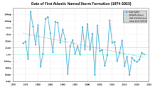
While Arlene wasn't a May storm, the tropical depression from which it emerged from had already developed on the very first day of the Atlantic hurricane season on June 1. Last year’s first named storm — Alex — formed on June 5. And between 2015 and 2021, all seven named storms formed in the month of May.
According to Brian McNoldy, Senior Research Associate at the University of Miami’s Rosentiel School of Marine, Atmospheric and Earth Science, “over the past fifty years, the trend of the date of first named storm is decidedly getting earlier.” There has been talk of moving the starting date of the Atlantic hurricane season to May 15, but after much discussion, we went into 2023 with that date still fixed at June 1.
Get South Florida local news, weather forecasts and entertainment stories to your inbox. Sign up for NBC South Florida newsletters.
The reason for the earlier storms is clear: the Atlantic Ocean is being warmed by climate change. Warmer water also extends deeper into the calendar year, which is partly to blame for Hurricane Nicole’s robust pounding of Florida’s east coast in November 2022.
Warm sea surface temperatures aren’t just present for more months each year, but are also expanding geographically. That’s how a subtropical storm was able to form this January (yes, January) off the northeastern coast of the United States. So, technically, Arlene is the second tropical system of 2023 in the Atlantic basin!
Hurricane Season
The NBC 6 First Alert Weather team guides you through hurricane season
The good news about Tropical Storm Arlene is that it is expected to dissipate soon. Upper level winds are becoming increasingly hostile over the Gulf of Mexico. The storm was already a bit lopsided on Friday, with the low level center of circulation partially separated from the strongest areas of rain and thunderstorms. As wind shear continues to tilt Arlene, dissipation is expected over the weekend.
That’s good news for Cuba — where Arlene’s path points to — because the system is expected to arrive there as a remnant low-pressure area with maximum winds of only 25 mph.
The indirect effects in Florida from Arlene continue to manifest in the form of waves of strong rain and thunderstorms. A lot of the rain is happening in the afternoons and evenings, when we get an additional vertical shove from the increasingly buoyant air that’s in contact with the hot ground.
NOAA’s Storm Prediction Center predicts a marginal risk of excessive rain in South Florida through the weekend, with the possibility of flash flooding. There is an 80% chance of rain on Saturday. As a result, the National Weather Service’s South Florida office has placed the entire region under a Flood Watch through at least late Saturday night.
Beyond Arlene, there’s not much to worry about in the Atlantic. Even though the National Hurricane Center expanded their Tropical Weather Outlook bulletins to look forward as far as seven days instead of five, at this time there are no other areas of concern.
John Morales is NBC6's Hurricane Specialist.
