
Thursday was a good day, namely for all of us in the Bahamas and South Florida. The disturbance in the Atlantic arrived at the Turks and Caicos Islands in such a dilapidated state, that the risk of a strong cyclone emerging from the warm waters of the Bahamas has diminished tenfold.
The sea surface temperatures in the area where Invest 99L will enter by Friday morning are still hot, generally 85 to 90 degrees. But it heads into that region in the worst state it’s been in over its entire lifetime since we started tracking it a little over a week ago.
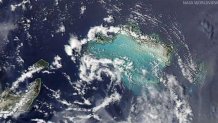
Basically (as you can see in the attached picture) it’s just a swirl of clouds, devoid of thunderstorms. All of the thunderstorms spent the day displaced to the east and southeast, thanks to westerly upper level wind shear. The shear has been stronger and longer lasting than anticipated, and it has torn Invest 99L apart.
Tropical systems like to have light winds aloft to allow for updrafts of moist air and thunderstorms to grow vertically and unimpeded, and that’s obviously not been the case of late for this disturbance.
While winds aloft may relax somewhat by Saturday, by then it may be too late for Invest 99L to gain any significant strength. Even the European model, which for six straight runs over the course of three days insisted on a strong tropical storm or hurricane hitting Miami, has backed off big time.
With that in mind, the National Hurricane Center tonight dropped the chances for a tropical depression or storm to form within the next two days to just 30 percent. While there’s still a 60 percent chance that a depression or storm may form within the next five days, by then the system would be well away from South Florida.
Local


As you might imagine (and you saw on TV), I am feeling very upbeat this evening knowing that what our area will see may be limited to heavy rain and some squalls, but that the chances of a hurricane are slim now, and what I yesterday declared as "not impossible" is looking pretty impossible right now.
The exact timing of the rain and gusty wind event has yet to be determined, but it appears the heaviest of the precipitation would fall in the period from late Sunday through Tuesday. Several inches of rain are possible.
