
What to Know
- Tropical storm Laura slowed to 40 miles per hour Saturday
- A Hurricane Hunter aircraft found the center of Laura south of its previously estimated position
- Meanwhile, Tropical Storm Marco formed over the northwestern Caribbean
Tropical Storm Laura approached the Greater Antilles early Saturday as Tropical Storm Marco formed over the northwestern Caribbean.
Laura had maximum sustained winds of 40 mph and was moving west at 21 mph about 70 miles southeast of San Juan, Puerto Rico, according to the 5 a.m. update from the National Hurricane Center in Miami.
HURRICANE SEASON 2020
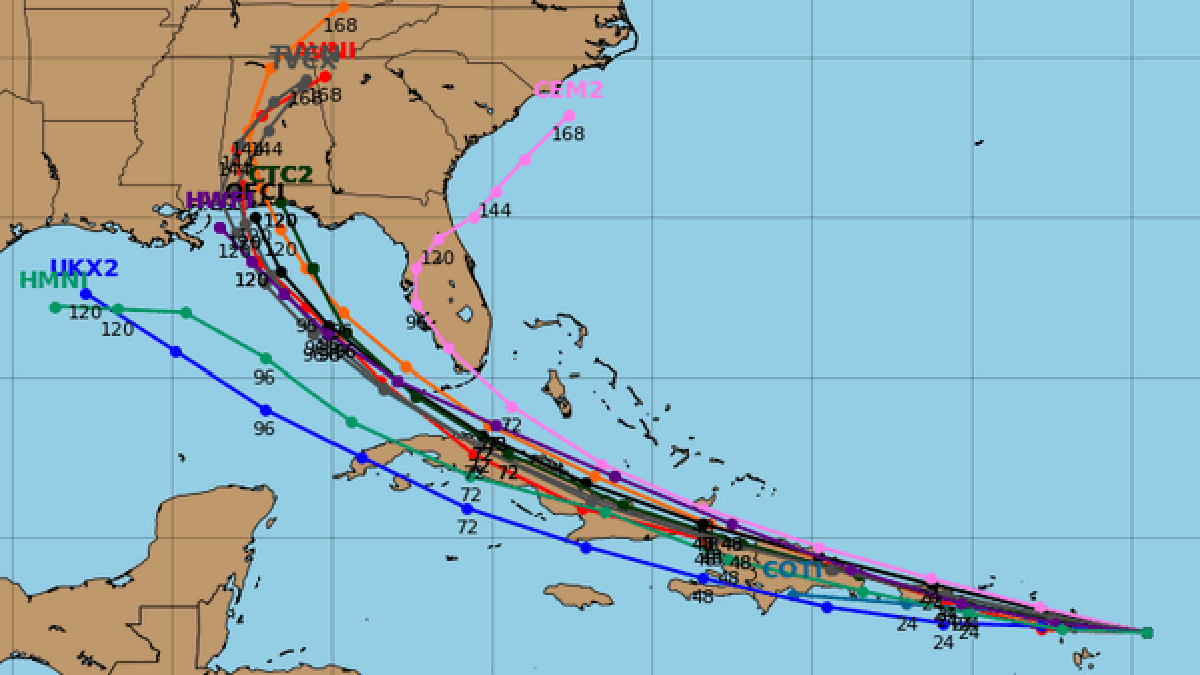
The NHC's official track forecast was adjusted to the south Friday, removing a large portion of South Florida from the cone of concern.
With most of the Florida Keys remaining in the cone, Monroe County issued a state of local emergency Friday and will open up the county's Emergency Operations Center in advance of the storm's potential track, officials said. A mandatory evacuation order has also issued for all liveaboard vessels, mobile homes, recreational vehicles, travel trailers, and campers.
Tropical storm warnings were in effect for the southeastern Bahamas and Turks and Caicos Islands, Puerto Rico, Vieques and Culebra, the Dominican Republic, the U.S. Virgin Islands, the British Virgin Islands, Saba and Eustatius, St. Maarten, St. Martin and St. Barthelemy.
A tropical storm watch was in effect for the central Bahamas.
Stay up to date with NBC 6 First Alert Weather and South Florida's most powerful radar First Alert Doppler 6000 by downloading the NBC 6 app for iOS or Android.
Rainfall between one and six inches was expected across the Caribbean.
On the forecast track, the center of Laura will move near or over portions of the Leeward Islands Friday night, near or over Puerto Rico Saturday morning, and near the northern coast of Hispaniola Saturday night and early Sunday.
As it stands now, the official track keeps the system north of Cuba and south of the Bahamas late Sunday into Monday morning. If the system remains intact at this point, it could strengthen as it makes its final approach to South Florida on Monday.
Meanwhile, Tropical Storm Marco formed late Friday and had maximum sustained winds of 40 mph as it moved north-northwest about 180 miles southeast of Cozumel, Mexico.
The center of Marco will approach the east coast of the Yucatan Peninsula of Mexico on Saturday. The center will then cross the northeastern part of the Yucatan Peninsula Saturday night and move over the central Gulf of Mexico toward the northwestern Gulf on Sunday and Monday, forecasters said.
A hurricane watch is in effect from Punta Herrero to Cancun, Mexico while a tropical storm warning is in effect from the border of Honduras and Nicaragua to Punta Herrero, Bay Islands of Honduras, Puerto Cabezas, Nicaragua northward to the border with Honduras and from Punta Herrero to Cancun, Mexico. Rainfall is expected to be anywhere from one to 10 inches across the area.
