


The first half of the 2022 Atlantic hurricane season was surprisingly quiet. Barely into the second half of the season and the Atlantic has spawned five tropical cyclones in a little over three-weeks' time.
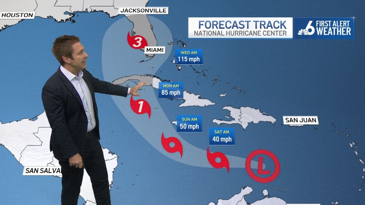
Tropical Depression Nine is the latest. It formed early Friday morning in the Caribbean Sea off the north coast of Venezuela. TD 9 was moving west-northwest in the general direction of Jamaica and the Cayman Islands where it could arrive on Sunday, according to the National Hurricane Center’s (NHC) forecast.
Because of the very warm waters of the western Caribbean, it is forecast to reach the Caymans at hurricane strength. All signs point to further intensification.
Besides a deep pool of warm water which is as hot as 87-degrees (30.4 °C) at the ocean surface, upper level winds are expected to become much more conducive for the depression to quickly step up to tropical storm and eventually hurricane strength. These ideal conditions are expected to be in place between Sunday and Monday when the system is south of Cuba. Therefore, NHC is forecasting a Category 2 hurricane to hit Cuba on Monday night.
Get South Florida local news, weather forecasts and entertainment stories to your inbox. Sign up for NBC South Florida newsletters.
While there are mountains in western Cuba—mostly in Pinar del Río province—the highest peaks are just slightly taller than 2000 feet. It’s uncertain how much land interaction with Cuba could weaken the future hurricane. NHC is forecasting for the system to emerge from Cuba essentially unscathed and then ramp up further in strength as it approaches Florida.
The official forecast as of early Friday morning is for a near-Category 3 hurricane to pass near or over the Florida Keys on Tuesday and near or over southern Florida on Tuesday night.
There is still quite a bit of uncertainty regarding that forecast track.
The reason the depression, once stronger, is expected to turn north, is a dip in the jet stream that’s forecast to reach the eastern third of North America as far south as the Gulf of Mexico by Monday. The exact timing and nature of a connection between a tropical cyclone in the tropics and a northern-latitude jet stream is always tricky.
Earlier, the computer forecast models showed a wide range of possibilities, including that the storm would miss the connection to the upper level trough. On Friday there was greater consensus among them that the tropical system would indeed link up with that dip in the jet stream. That’s why the NHC forecast shows that sharp right-hand turn after the Caymans.
As things stand on Friday, it is impossible to determine which part of Florida might see the worst from this storm early next week. That won’t be known for a couple of days.
For now, all Floridians, from the Panhandle to the Keys, need to dust off their hurricane emergency plans and heed the advice of local authorities. Expect a Hurricane Watch to be issued for parts of the state by Sunday, most likely initially for the Florida Keys.
As the station’s hurricane specialist, I will be on all evening newscasts on Friday and through the weekend on NBC 6.

