Loma Prieta: Looking Back on the Earthquake 30 Years Later
The 6.9 magnitude quake on Oct. 17, 1989 left 63 people dead and more than 3,700 injured
•
The Bay Area marks the 30th anniversary of the Loma Prieta earthquake on October 17th. If you were in the Bay Area on that day in 1989, you knew where you were and what you were doing at 5:04 p.m. when the 6.9 quake rocked the region. In this installment of our award-winning documentary, we’ll take a look at how…
Thirty years ago Thursday, the Loma Prieta earthquake rocked the Bay Area and beyond, shaking buildings from their foundations, flattening a stretch of freeway in Oakland and dislodging a section of the Bay Bridge.
The 6.9 magnitude earthquake, which struck at 5:04 p.m. on Oct. 17, 1989, left 63 people dead, injured more than 3,700 others and caused billions of dollars' worth in damage.
Baseball fans across the Bay Area were gearing up to watch Game 3 of the World Series between the San Francisco Giants and Oakland Athletics when the quake struck on the San Andreas Fault near Loma Prieta peak in the Santa Cruz Mountains.
"When I went outside as this thing was happening, you could actually see the wave that was coming from the south going north. It made every car jump in the air," San Francisco resident Dr. Steven Brattesani said in a recent Bay Area Revelations episode chronicling the earthquake's widespread devastation. "I mean, I've never seen concrete and asphalt do that before."
AP
In this photo taken Oct. 17, 1989, motorists turn their cars around and wait to drive back to San Francisco after the upper deck of the Bay Bridge collapsed onto the lower deck in the Loma Prieta earthquake in San Francisco.
UIG via Getty Images
Loma Prieta, California, Earthquake October 17, 1989.
ASSOCIATED PRESS
A U. S. Marine guard watches the earthquake-damaged area of San Francisco, Cal., October 17, 1989, to avoid thieving.
Getty Images
General view of debris after the earthquake, measuring 7.1 on the Richter scale.
ASSOCIATED PRESS
A worker tries to clear a drain to release backed up water from broken mains and firefighting efforts in the Marina District of San Francisco Wednesday morning, Oct. 18, 1989.
ASSOCIATED PRESS
Rescue dogs are brought into position to begin searches of destroyed houses in the Marina district of San Francisco, Wednesday morning, October 18, 1989, after a strong earthquake caused widespread damage.
ASSOCIATED PRESS
Firefighters put out fires as some buildings smoulder while others are off their foundations in the Marina District of San Francisco, Ca., after the massive earthquake, Wednesday, Oct. 18, 1989.
ASSOCIATED PRESS
A bulldozer brings down a damaged apartment complex in the Marina district of San Francisco, Ca., as people watch from the roof of another building, Wednesday afternoon, Oct. 18, 1989.
Getty Images
General view of debris after the earthquake, measuring 6.9 on the richter scale.
AFP/Getty Images
Search and rescue support workers Tim Schilwachder (L) and Mamdouch Shabaan embrace 21 October 1989 by the Cypress Structure above 28th and Cypress Sts, shortly after a man was rescued alive there.
AFP/Getty Images
Cranes surround the Cypress Structure on Interstate 880 October 19, 1989 in San Francisco, following the earthquake.
ASSOCIATED PRESS
Two firefighters scale a ladder Wednesday, Oct. 18, 1989 to survey the wreckage of an apartment in San Francisco's Marina district. The temblor caused severe damage to many parts of the Bay area.
ASSOCIATED PRESS
Paul Barwick, right, hands a television set to his friend Frank (last name not given) as they help a resident of the Marine district remove valuables from his braced up home Friday, Oct. 21, 1989 in San Francisco. Residents were given 15 minutes to take items from their earthquake damaged homes, many of which were demolished.
CHRIS WILKINS/AFP/Getty Images
Search and rescue support workers continue rescue efforts 21 October 1989 atop the Cypress Structure above 28th and Cypress Sts, shortly after a man was rescued alive there.
Getty Images
A general view of the freeway in Oakland after the Loma Prieta earthquake hit prior to World Series game three between the Oakland Athletics and San Francisco Giants on October 18, 1989 at Candlestick Park in San Francisco, California. The game was postponed for 10 days.
ASSOCIATED PRESS
Sherman Chen searches through what is left of the family home in the Marina district of San Francisco Tuesday, Oct. 24, 1989. The home was so unstable after the earthquake that it was torn down before family members could remove any valuables. Chen searched until police forced him to leave the area.
Getty Images
A general view of a street in San Francisco after the Loma Prieta earthquake hit prior to World Series game three between the Oakland Athletics and San Francisco Giants on Oct. 18, 1989 at Candlestick Park.
ASSOCIATED PRESS
A bridge worker checks bolt hole alignment and readies to attach a support fro I-beams that will span the gaping hole created in the San Francisco-Oakland Bay Bridge October 17 by the earthquake.
ASSOCIATED PRESS
Jim Vallas, Cal Trans residents engineer, right, discusses progress of repair on the San Francisco-Oakland Bay Bridge, Friday, Nov. 3, 1989, Oakland, Calif. This section was dislodged in the October 17 earthquake. Some supports for I-beams that will span the break are in place and can be seen on both decks at T-s. Steel I-beams have been delivered to the site.
ASSOCIATED PRESS
This aerial view is the last standing section of the nearby-demolished Cypress section of the I-800 Nimitz freeway, Jan. 11, 1990, Oakland, Calif. 42 people lost their lives on the freeway. The standing section was used for seismic testing and was gone by the end of January, 1990.
ASSOCIATED PRESS
Paramedics and police remove one of victims of the collapse of the Cypress freeway at the height of commute traffic, Tuesday, Oct. 18, 1989, Oakland, Calif.
ASSOCIATED PRESS
A burned out vehicle lies at the base of a broken column that once supported two decks of the Cypress freeway, Oct. 18, 1989, Oakland, Calif.
ASSOCIATED PRESS
Vendor Nicole Verment of Spokane, Wash., was doing a brisk business on Hegenberger Rd. near the Oakland Coliseum with this T-shirt: I Survived The Great Quake, Thursday, Oct. 19, 1989, Oakland, Calif.
ASSOCIATED PRESS
Bob Kubiatowicz, left, and John Wooliscroft look at whats left of a neighbors home, Friday, Oct. 21, 1989, Boulder Creek, Calif. Kubiatowiczs home was untouched while Wooliscrofts suffered the same fate as that pictured. All three homes are on the same mountainside road.
ASSOCIATED PRESS
Juanito Garcia, center, whose home was severely damaged by Tuesdays earthquake, eats outside the temporary quarters of his family, Saturday, Oct. 21, 1989, Watsonville, Calif. Hundreds of the areas residents were forced to move into tent shelters following the quake.
ASSOCIATED PRESS
Glen Ward, on wing, unloads his aircraft and passes relief supplies from man to a flatbed truck at the airport, Sunday, Oct. 23, 1989 Watsonville, Calif. Ward, who makes 8-9 round trips per day, is one of many private pilots that fly in needed good for earthquake victims.
ASSOCIATED PRESS
Erica Alfaro, center, dishes up lunch for her cousin Sergio Alfaro under a tent as rain falls at a relief center, Monday, Oct. 24, 1989, Watsonville, Calif. The 6.9 earthquake destroyed their home. Marylou Ortiz uses a blanket, rear, to protect her from the rain as she walks through the mud to a tent made of plastic sheeting.
ASSOCIATED PRESS
Rubble litters the ground as workers continue to tear down a section of the I-880 Cypress structure, Wednesday, Oct. 25, 1989, Oakland, Calif. The demolition allowed evacuated families to move back into their homes following the earthquake.
ASSOCIATED PRESS
The demolition of the I-880 Cypress structure and its dangerous proximity to the residences of West Oakland are mirrored in the glasses of Oakland Housing Authority police officer Price Holbert who wears a fiber mask to protect him from heavy dust, Oct. 26, 1989, Oakland, Calif.
ASSOCIATED PRESS
Workers add one of the last sections of the lower deck of the Bay Bridge, Tuesday, Nov. 7, 1989, Oakland, Calif. This section of the bridge collapsed during the October 17 earthquake.
AP
In this file photo taken Oct. 17, 1989 firefighters battle a blaze in the Marina District of San Francisco after the earthquake.
ASSOCIATED PRESS
Football fans arriving Sunday's game between the San Francisco 49ers and the New England patriots contribute to earthquake relief organizations outside Stanford Stadium, Oct. 23, 1989. The game was moved to Stanford while to allow workers time to repair Candlestick Park, the 49ers home field, and prepare it for the World Series games which were postponed by the quake.
ASSOCIATED PRESS
Suzanne Kleiman, a resident of San Francisco's Marina district holds up a pair of panty hose she found while searching through the rubble of her demolished home, Wednesday, Oct. 25, 1989. Kleiman was one of many residents who continued to search for their belongings in their earthquake-damaged homes before the rubble was hauled away.
AP
Suzanne Kleiman, a resident of San Francisco's Marina district, Oct. 26, 1989, climbs down from the remains of what was once her home, after searching for some of her belongings Wednesday.
ASSOCIATED PRESS
Workers use lumber to shore up a quake-damaged building in San Francisco's Marina district, Sunday, Oct 23, 1989 to prevent it from collapsing.
ASSOCIATED PRESS
With children in strollers, pets on leashes and belongings under arm, a family leaves its earthquake-damaged home in San Francisco's Marine district, Thursday, Oct. 28, 1989. Residents were allowed to return to damaged buildings which were determined to be structurally safe to retrieve their belongings.
ASSOCIATED PRESS
A group of people stand in the South of Market street, Wednesday, Nov. 1, 1989 in San Francisco, where five people died under a torrent of bricks when the 15-second quake two weeks ago wrenched off the top of a four-storey building in San Francisco.
The epicenter was located roughly nine miles northeast of Santa Cruz and 60 miles south-southeast of San Francisco, according to the U.S. Geological Survey.
Shaking was said to have lasted for about 15 to 20 seconds, and people as far away as San Diego and western Nevada reportedly felt it, according to the California Department of Conservation.
"The 1989 Loma Prieta earthquake ended decades of tranquility in the San Francisco Bay region," Robert Page with the USGS said in a statement. "It was a wakeup call to prepare for the potentially even more devastating shocks that are inevitable in the future."
We take a look at how different the Bay Area looks, 30 years after the Loma Prieta earthquake hit.
The quake damaged an estimated 18,300 houses, according to the conservation department. Another 963 were destroyed. The shaking also damaged nearly 2,600 businesses and wiped out 147.
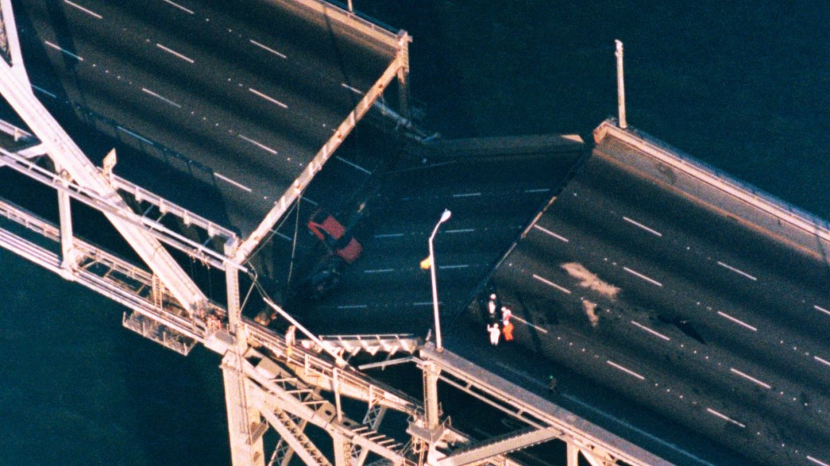
Tremors caused a portion of the upper deck of the Bay Bridge to collapse onto the lower deck, leaving the vital transportation artery unusable for about one month. The upper deck of the nearby Cypress Freeway in Oakland also came crashing down in an instant, crushing cars on the freeway's lower level. Forty-two people were killed.
"I'm looking over and I remember seeing a woman in a brand new BMW. She was in that car, and there was a gardener guy [in] a little Toyota pickup or whatever. And then, 'Wham!' It was lights out," Tim Petersen, a 24-year-old firefighter at the time of the earthquake, recalled in an interview with Bay Area Revelations. "Everything went black."
Petersen, pinned in his flattened pickup truck, suffering from two broken ankles, broken ribs on his left side and an injured shoulder, managed to survive thanks to Oakland firefighters who spent six hours pulling him to safety.
"I was getting ready to just see what it's like to die," Petersen said. "It's going to be over real soon, and I was waiting. And it never happened."
It was 5:04 p.m. on October 17, 1989, when a powerful magnitude 6.9 earthquake shook the soft soil of San Francisco’s Marina District, crumpling the neighborhood’s old wooden buildings like paper, and sending a cascade of splintered wood and glass into the streets. With water pipes and fire hydrants disabled by the quake, the fire department responded with a rarely-used...
Over in San Francisco, the soft soil of the Marina District gave way. Homes toppled, gas lines ruptured and blazes ignited.
"It was mayhem," Brattesani said. "Buildings were in the street. All the corner buildings were literally from four stories to one story."
Brick buildings in downtown Santa Cruz crumpled.
"Streets were just a tumble of bricks and building parts," Ceil Cirillo, former Santa Cruz redevelopment director, said.
C.E. Meyer, U.S. Geological Survey
Ground view of collapsed building and burned area shown in photo 4, Beach and Divisadero, Marina District. [C.E. Meyer, U.S. Geological Survey]
J.K. Nakata, U.S. Geological Survey
Tom Brokaw of NBC News prepares script for a live broadcast from the Marina District. [J.K. Nakata, U.S. Geological Survey]
H.G. Wilshire, U.S. Geological Survey
Side view of support-column failure and collapsed upper deck, Cypress viaduct. [H.G. Wilshire, U.S. Geological Survey]
C.E. Meyer, U.S. Geological Survey
Cars crushed by collapsing brick facade near Fifth and Townsend Streets. At this locality, five people were killed while leaving from work. [C.E. Meyer, U.S. Geological Survey]
C.E. Meyer, U.S. Geological Survey
Crushed car near the intersection of Fifth and Townsend Streets, South of Market. [C.E. Meyer, U.S. Geological Survey]
C.E. Meyer, U.S. Geological Survey
Aerial view of collapsed buildings and burned-out section at Beach and Divisadero Streets, Marina District. [C.E. Meyer, U.S. Geological Survey]
C.E. Meyer, U.S. Geological Survey
Demolition of collapsed building and watering down of burned area, October 18, 1989, Beach and Divisadero Streets, Marina District. [C.E. Meyer, U.S. Geological Survey]
J.K. Nakata, U.S. Geological Survey
Absence of adequate shear walls on the garage level exacerbated damage to this structure at the corner of Beach and Divisadero Streets, Marina District. [J.K. Nakata, U.S. Geological Survey]
C.E. Meyer, U.S. Geological Survey
Entrance and garage level of a Beach Street apartment complex in danger of collapse, Marina District. [C.E. Meyer, U.S. Geological Survey]
J.K. Nakata, U.S. Geological Survey
An automobile lies crushed under the third story of this apartment building in the Marina District. The ground levels are no longer visible because of structural failure and sinking due to liquefaction. [J.K. Nakata, U.S. Geological Survey]
C.E. Meyer, U.S. Geological Survey
Collapsed brickwork from a corner apartment building, Marina District. [C.E. Meyer, U.S. Geological Survey]
J.K. Nakata, U.S. Geological Survey
Smoldering remains of the apartment complex at the corner of Beach and Divisadero Streets, Marina District. [J.K. Nakata, U.S. Geological Survey]
J.K. Nakata, U.S. Geological Survey
A search and rescue team, Marina District. [J.K. Nakata, U.S. Geological Survey]
J.K. Nakata, U.S. Geological Survey
Electric wires being removed from unstable towers by city utility workers. Arresting sparks from broken wires was a priority in those areas with broken gas mains. [J.K. Nakata, U.S. Geological Survey]
C.E. Meyer, U.S. Geological Survey
Aerial view of roadbed collapse near the interface of the cantilever and truss sections of the San Francisco-Oakland Bay Bridge. View northwestward. [C.E. Meyer, U.S. Geological Survey]
C.E. Meyer, U.S. Geological Survey
Aerial view of the collapsed section of the San Francisco-Oakland Bay Bridge. View westward. [C.E. Meyer, U.S. Geological Survey]
J.C. Tinsley, U.S. Geological Survey
Sand boil or sand volcano measuring 2 m (6.6 ft) in length erupted in median of Interstate Highway 80 west of the Bay Bridge toll plaza when ground shaking transformed loose water-saturated deposit of subsurface sand into a sand-water slurry (liquefaction). Vented sand contains marine-shell fragments. [J.C. Tinsley, U.S. Geological Survey]
H.G. Wilshire, U.S. Geological Survey
Aerial view of collapsed sections of the Cypress viaduct of Interstate Highway 880. [H.G. Wilshire, U.S. Geological Survey]
H.G. Wilshire, U.S. Geological Survey
Aerial view of collapsed sections of the Cypress viaduct of Interstate Highway 880. [H.G. Wilshire, U.S. Geological Survey]
J.K. Nakata, U.S. Geological Survey
Reinforcement bars exposed at the base of the Cypress viaduct near 14th Street. [J.K. Nakata, U.S. Geological Survey]
Remnant portion of the north- and south-bound Cypress viaduct exposing box girders near 14th Street. [J.K. Nakata, U.S. Geological Survey]
H.G. Wilshire, U.S. Geological Survey
Support-column failure and collapsed upper deck, Cypress viaduct. [H.G. Wilshire, U.S. Geological Survey]
H.G. Wilshire, U.S. Geological Survey
Bent reinforcement bars in failed support column, Cypress viaduct. [H.G. Wilshire, U.S. Geological Survey]
H.G. Wilshire, U.S. Geological Survey
Closeup of damaged reinforcement bars from a Cypruss viaduct support column. [H.G. Wilshire, U.S. Geological Survey]
H.G. Wilshire, U.S. Geological Survey
Pancaked upper deck, Cypress viaduct. Guard rail at right is on lower deck. [H.G. Wilshire, U.S. Geological Survey]
H.G. Wilshire, U.S. Geological Survey
Sheared reinforcement bar, Cypress viaduct. [H.G. Wilshire, U.S. Geological Survey]
H.G. Wilshire, U.S. Geological Survey
Temporary support structures emplaced to prevent further collapse, Cypress viaduct. [H.G. Wilshire, U.S. Geological Survey]
J.K. Nakata, U.S. Geological Survey
Demolition of Cypress structure near 14th Street. [J.K. Nakata, U.S. Geological Survey]
J.K. Nakata, U.S. Geological Survey
A downtown building at the corner of Alice and 13th Streets lost part of its unreinforced facade and brick masonry. [J.K. Nakata, U.S. Geological Survey]
D.M. Peterson, U.S. Geological Survey
Cliff failure just south of San Gregorio Beach. Slide is 18.3 m (60 ft) high and displaces approximately 6881 cubic meters (9,000 cubic yards) of material. Large boulders are 1 m (3 ft) across. [D.M. Peterson, U.S. Geological Survey]
D.M. Peterson, U.S. Geological Survey
Cliff failure north of Tunitas Creek. This face continued to slide for a few days after the earthquake. The event in progress exposed dark cliff material. [D.M. Peterson, U.S. Geological Survey]
D.M. Peterson, U.S. Geological Survey
Landslide north of Fort Funston. Slide mass contains approximately 2,830 cubic meters (3,700 cubic yards) and is 30 m (100 ft) high. Photo 35 provides an aerial view of this slide. [D.M. Peterson, U.S. Geological Survey]
D.M. Peterson, U.S. Geological Survey
Headscarp of small slide at Redondo Beach. Scale is provided by the red-handled rock hammer, which is 30.5 cm (12 in.) long. [D.M. Peterson, U.S. Geological Survey]
S.D. Ellen, U.S. Geological Survey
Aerial view of large slides north of Fort Funston. A ground perspective of this slide is shown in photo 33. [S.D. Ellen, U.S. Geological Survey]
S.D. Ellen, U.S. Geological Survey
Aerial view of slide at Daly City. This is the largest slide triggered by the earthquake in San Mateo County, displacing approximately 36,700 cubic meters (48,000 cubic yards) of material. The base is about 152 m (500 ft) across at its widest point. [S.D. Ellen, U.S. Geological Survey]
H.G. Wilshire, U.S. Geological Survey
KGO radio transmission towers, built on bay mud in a salt-evaporation pond used by the Leslie Salt Company. Note progressively less damage to towers away from viewer. [H.G. Wilshire, U.S. Geological Survey]
J.K. Nakata, U.S. Geological Survey
Unfastened bookcases in an office building fell during the primary shock. [J.K. Nakata, U.S. Geological Survey]
J.K. Nakata, U.S. Geological Survey
Books and air-conditioning duct were dislodged during earthquake. [J.K. Nakata, U.S. Geological Survey]
J.K. Nakata, U.S. Geological Survey
Seismographs at the U.S. Geological Survey record the (1) north-south horizontal, (2) east-west horizontal and (3) vertical components of the October 17th earthquake. [J.K. Nakata, U.S. Geological Survey]
H.G. Wilshire, U.S. Geological Survey
Aerial view of collapsed five-story tower, St. JosephÍs Seminary. One person working in tower was killed. [H.G. Wilshire, U.S. Geological Survey]
H.G. Wilshire, U.S. Geological Survey
Aerial view of collapsed five-story tower, St. JosephÍs Seminary. [H.G. Wilshire, U.S. Geological Survey]
J.K. Nakata, U.S. Geological Survey
Nontectonic surface rupture across Highway 280 at the interface of a roadcut and fill area 2.5 km (1.5 mi) north of Foothill Expressway. [J.K. Nakata, U.S. Geological Survey]
J.K. Nakata, U.S. Geological Survey
The cement retaining walls along Highway 280 deformed in accordion-like pattern as a result of lateral compression. [J.K. Nakata, U.S. Geological Survey]
J.K. Nakata, U.S. Geological Survey
Failure of unreinforced brick masonry caused collapse of the upper floor in downtown Los Gatos. [J.K. Nakata, U.S. Geological Survey]
J.K. Nakata, U.S. Geological Survey
Photograph taken in a ceramics shop during an aftershock. [J.K. Nakata, U.S. Geological Survey]
J.K. Nakata, U.S. Geological Survey
Books lie scattered in aisles of a downtown bookstore. [J.K. Nakata, U.S. Geological Survey]
J.K. Nakata, U.S. Geological Survey
Many residents camped in their yards after the earthquake. [J.K. Nakata, U.S. Geological Survey]
C.E. Meyer, U.S. Geological Survey
Personal messages posted on van at Emergency Center. [C.E. Meyer, U.S. Geological Survey]
C.E. Meyer, U.S. Geological Survey
Vehicle crushed by collapse of unreinforced-brick masonry. [C.E. Meyer, U.S. Geological Survey]
H.G. Wilshire, U.S. Geological Survey
Failure of porch on frame house. [H.G. Wilshire, U.S. Geological Survey]
R.A. Haugerud, U.S. Geological Survey
Drain grating shows the effects of lateral compression. [R.A. Haugerud, U.S. Geological Survey]
J.K. Nakata, U.S. Geological Survey
Downtown sidewalk buckled due to compression. [J.K. Nakata, U.S. Geological Survey]
H.G. Wilshire, U.S. Geological Survey
Crack system with 1.2 m (4 ft) of vertical displacement across a clay tennis court; fracture passes across retaining wall and up slope beyond view. West of Summit Road, southeast of Highway 17. [H.G. Wilshire, U.S. Geological Survey]
J.K. Nakata, U.S. Geological Survey
A crack system destroys driveway adjacent to summit road 0.8 km (1/2 mi) southeast of Highway 17. [J.K. Nakata, U.S. Geological Survey]
J.K. Nakata, U.S. Geological Survey
A geologist traces surface cracks in a corral adjacent to summit road approximately 1.6 km (1 mi) southeast of Highway 17. [J.K. Nakata, U.S. Geological Survey]
R.J. McLaughlin, U.S. Geological Survey
Northwest-trending extensional crack where dam fill settled about 0.6 m (2 ft) and pulled away from concrete spillway and north abutment of Austrian Dam. [R.J. McLaughlin, U.S. Geological Survey]
G.R. Fisher, U.S. Geological Survey
Prominent northwest-trending extensional cracks up to 12 cm (4.7 in.) wide in concrete spillway to Austrian Dam, north abutment. [G.R. Fisher, U.S. Geological Survey]
J.K. Nakata, U.S. Geological Survey
Geologist exchanging information with rescue personnel. [J.K. Nakata, U.S. Geological Survey]
J.K. Nakata, U.S. Geological Survey
Bedroom showing effects of the earthquake. [J.K. Nakata, U.S. Geological Survey]
J.K. Nakata, U.S. Geological Survey
House destroyed by failure of downslope support piers. [J.K. Nakata, U.S. Geological Survey]
J.K. Nakata, U.S. Geological Survey
House moved laterally off cement foundation. [J.K. Nakata, U.S. Geological Survey]
J.K. Nakata, U.S. Geological Survey
Collapsed garage built on fill. [J.K. Nakata, U.S. Geological Survey]
J.K. Nakata, U.S. Geological Survey
Construction on fill and the absence of adequate shear walls ccontributed to the failure of this structure. [J.K. Nakata, U.S. Geological Survey]
J.K. Nakata, U.S. Geological Survey
House torn off its foundation by the main shock. [J.K. Nakata, U.S. Geological Survey]
C.E. Meyer, U.S. Geological Survey
Landslide debris blocks both eastbound lanes of Highway 17 near Summit Road. [C.E. Meyer, U.S. Geological Survey]
C.E. Meyer, U.S. Geological Survey
Landslide debris blocks both eastbound lanes of Highway 17 near Summit Road. Foreground material is damaged lane separators. [C.E. Meyer, U.S. Geological Survey]
J.K. Nakata, U.S. Geological Survey
This roadcut near Summit Road failed during the initial earthquake and subsequent aftershocks. To mitigate further sliding, Caltrans decreased the slope angle. [J.K. Nakata, U.S. Geological Survey]
C.E. Meyer, U.S. Geological Surve
Damaged lane separators, Highway 17. [C.E. Meyer, U.S. Geological Survey]
R.A. Haugerud, U.S. Geological Survey
Broken concrete divider near the intersection of Summit Road and Highway 17. [R.A. Haugerud, U.S. Geological Survey]
J.C. Tinsley, U.S. Geological Survey
Clock tower near north end of Pacific Garden Mall. Not known if clock was fast or if it ran for about 6 minutes after the earthquake. [J.C. Tinsley, U.S. Geological Survey]
C.E. Meyer, U.S. Geological Survey
Bicycles crushed by falling unreinforced brick facade, Pacific Garden Mall. [C.E. Meyer, U.S. Geological Survey]
C.E. Meyer, U.S. Geological Survey
Collapsed unreinforced-brick facade, Pacific Garden Mall. [C.E. Meyer, U.S. Geological Survey]
C.E. Meyer, U.S. Geological Survey
Rescue efforts, Pacific Garden Mall. [C.E. Meyer, U.S. Geological Survey]
C.E. Meyer, U.S. Geological Survey
Removal of debris while searching for victims, Pacific Garden Mall. [C.E. Meyer, U.S. Geological Survey]
C.E. Meyer, U.S. Geological Survey
Searching for victims at collapsed department store, Pacific Garden Mall. [C.E. Meyer, U.S. Geological Survey]
C.E. Meyer, U.S. Geological Survey
Storefront damage, Pacific Garden Mall. [C.E. Meyer, U.S. Geological Survey]
J.K. Nakata, U.S. Geological Survey
"Unsafe to occupy" signs were posted by the Governor's Office of Emergency Services. [J.K. Nakata, U.S. Geological Survey]
J.K. Nakata, U.S. Geological Survey
Collapsed outer wall of the Medico Dental Building, Pacific Garden Mall. [J.K. Nakata, U.S. Geological Survey]
H.G. Wilshire, U.S. Geological Survey
Closeup of collapsed wall of unreinforced masonry, Medico Dental Building in the Pacific Garden Mall. [H.G. Wilshire, U.S. Geological Survey]
J.C. Tinsley, U.S. Geological Survey
Liquefaction in recent deposits of San Lorenzo River caused cracking and differential settling of river levee southeast of Riverside Avenue Bridge. Bridge piers and the north abutment area were also damaged by liquefaction. [J.C. Tinsley, U.S. Geological Survey]
J.C. Tinsley, U.S. Geological Survey
Landslide-displaced trees reflect earthquake-triggered slope failure along coastal bluff, New Brighton Beach area, Santa Cruz County. [J.C. Tinsley, U.S. Geological Survey]
J.C. Tinsley, U.S. Geological Survey
Liquefaction in recent deposits of the Pajaro River formed these sand volcanoes along extensional fissures in a field prepared for autumn planting near Pajaro, across the Pajaro River from Watsonville. Furrows are spaced about 1.2 meters (4 feet) apart. [J.C. Tinsley, U.S. Geological Survey]
J.C. Tinsley, U.S. Geological Survey
Vent of sand volcano produced by liquefaction is about 4 feet across in strawberry field near Watsonville. Strip spanning vent is conduit for drip irrigation system. Furrow spacing is about 1.2 meters (4 feet) on center. [J.C. Tinsley, U.S. Geological Survey]
J.C. Tinsley, U.S. Geological Survey
Liquefaction in recent deposits of the Pajaro River formed sand volcanoes along a fissure 6-7 meters (19.7-23 feet) in length. Variation in grain size and partial erosion of the conical deposits of sand show that venting of the slurry of sand and water was a complex series of depositional and erosional events triggered by the main shock and renewed in some instances by principal aftershocks. [J.C. Tinsley, U.S. Geological Survey]
S.D. Ellen, U.S. Geological Survey
Ground shaking triggered liquefaction in a subsurface layer of sand, producing differential lateral and vertical movement in a overlying carapace of unliquified sand and silt, which moved from right to left towards the Pajaro River. This mode of ground failure, termed "lateral spreading", is a principal causet of liquefaction-related earthquake damage. [S.D. Ellen, U.S. Geological Survey]
H.G. Wilshire, U.S. Geological Survey
Crack down front of Ford's Department Store, downtown Watsonville. Although this fracture appears minor, the building suffered significant damage. [H.G. Wilshire, U.S. Geological Survey]
J.K. Nakata, U.S. Geological Survey
Houses not bolted down securely were easily dislodged from their foundations in downtown Watsonville. [J.K. Nakata, U.S. Geological Survey]
J.K. Nakata, U.S. Geological Survey
Many homeowners buttressed their foundations to prevent further damage from aftershocks in downtown Watsonville. [J.K. Nakata, U.S. Geological Survey]
H.G. Wilshire, U.S. Geological Survey
Broken utility lines in house that shifted off its foundation, downtown Watsonville. [H.G. Wilshire, U.S. Geological Survey]
J.K. Nakata, U.S. Geological Survey
This house was dislodged from its foundation and moved 0.75 meters (2.5 feet) from the cement stairway in downtown Watsonville. [J.K. Nakata, U.S. Geological Survey]
J.C. Tinsley, U.S. Geological Survey
Structural failure of twin bridges carrying Highway 1 across Struve Slough, near Watsonville. [J.C. Tinsley, U.S. Geological Survey]
J.K. Nakata, U.S. Geological Survey
Close-up of collapsed bridge section on Highway 1 at Struve Slough. [J.K. Nakata, U.S. Geological Survey]
J.K. Nakata, U.S. Geological Survey
Failure at the joist/columns interface contributed to the collapse of elevated road bed on Highway 1. [J.K. Nakata, U.S. Geological Survey]
H.G. Wilshire, U.S. Geological Survey
Support columns of Highway 1 bridge across Struve Slough protrude through road bed. This resulted from collapse of the road bed after the effects of lateral shaking shown in photo 98. [H.G. Wilshire, U.S. Geological Survey]
H.G. Wilshire, U.S. Geological Survey
Support column of bridge across Struve Slough, Highway 1. Enlargement of hole where support enters the ground is an effect of lateral shaking. which caused the concrete to break up where the column joined the bridge and was instrumental in the roadbed collapse. [H.G. Wilshire, U.S. Geological Survey]
J.K. Nakata, U.S. Geological Survey
A fracture cuts the road bed, curbs and railings on the collapsed portion of Highway 1 at Struve Slough. [J.K. Nakata, U.S. Geological Survey]
J.C. Tinsley, U.S. Geological Survey
Liquefaction and subsequent strong tidal action destroyed causeway carrying the Moss Beach access road across tidewater basin near Moss Landing. [J.C. Tinsley, U.S. Geological Survey]
J.C. Tinsley, U.S. Geological Survey
Ground cracking and differential settlement owing to liquefaction of beach and Salinas River deposits damaged approach and abutment of bridge linking Moss Landing spit to the mainland, near Moss Landing Marine Laboratory. [J.C. Tinsley, U.S. Geological Survey]
S.D. Ellen, U.S. Geological Survey
Differential settlement due to liquefaction caused cracking of paved road on Paul's Island. [S.D. Ellen, U.S. Geological Survey]
J.C. Tinsley, U.S. Geological Survey
Partially razed earthquake-damaged unreinforced masonry buildings in Old Town historical district, City of Salinas. [J.C. Tinsley, U.S. Geological Survey]
Thirty years to the day Loma Prieta hit, people across the state on Thursday practiced their earthquake preparedness during the "Great California ShakeOut." The earthquake drill, which reminded people to drop, cover and hold, took place at 10:17 a.m., coinciding with the Loma Prieta anniversary.
"The Loma Prieta earthquake was a tragedy that caused immense suffering for thousands of California residents," California Earthquake Authority CEO Glenn Pomeroy said in a statement. "Anniversaries for big earthquakes often serve as painful reminders of why we need to know how to Drop, Cover, and Hold On when the ground shakes, and know how to financially recover from damage that may be expensive to repair."
Getty Images
In this before-and-after composite image, (Top) A worker surveys the damage caused by the fire in San Francisco's Marina District after the Loma Prieta earthquake struck on October 17, 1989 in San Francisco, California. (Photo by FEMA News Photo via Getty Images) (Bottom) A man waits for a bus on the corner of Beach and Divisadero on October 15, 2014 in San Francisco, California. It has been 25 years since the Loma Prieta earthquake rocked the San Francisco Bay Area at 5:04PM on October 17, 1989 causing widespread damage to buildings and roadways. 63 people died and nearly 4,000 were injured. (Photo by Justin Sullivan/Getty Images)
Getty Images
In this before-and-after composite image, (Left) Cars are seen covered in bricks from a falling building facade following the Loma Prieta earthquake on October 17, 1989 in San Francisco, California. (Photo by C.E. Meyer/U.S. Geological Survey Photographic Library via Getty Images) (Right) Cars are parked along 6th Street near Townsend on October 15, 2014 in San Francisco, California.
Getty Images
In this before-and-after composite image, (Top) The collapsed upper deck of the Cypress viaduct of Interstate 880 after the Loma Prieta earthquake on October 17, 1989 in Oakland, California. (Photo by H.G. Wilshire/U.S. Geological Survey Photographic Library via Getty Images) (Bottom) A car drives along Mandela Parkway where the Cypress viaduct of Interstate 880 used to stand on October 15, 2014 in Oakland, California. (Photo by Justin Sullivan/Getty Images)
Getty Images
In this before-and-after composite image, (Top) A view of the doorway to a damaged apartment building on Beach Street near Divisadero Street following the Loma Prieta earthquake on October 17, 1989 in San Francisco, California. (Photo by C.E. Meyer/U.S. Geological Survey Photographic Library via Getty Images) (Bottom) A view of a garage at an apartment building on Beach Street that was built after the 1989 Loma Prieta earthquake on October 15, 2014 in San Francisco, California. (Photo by Justin Sullivan/Getty Images)
Getty Images
In this before-and-after composite image, (Top) An apartment builing on the corner of Beach and Divisadero is seen shored up after the Loma Prieta earthquake struck on October 17, 1989 in San Francisco, California. (Photo by FEMA News Photo via Getty Images) (Bottom) Apartment buildings built after the 1989 Loma Prieta earthquake stand on the corner of Beach and Divisadero on October 15, 2014 in San Francisco, California (Photo by Justin Sullivan/Getty Images)
Getty Images
In this before-and-after composite image, (Top) A view of damaged homes along Divisadero Street following the Loma Prieta earthquake on October 17, 1989 in San Francisco, California. (Photo by G. Plafker/U.S. Geological Survey Photographic Library via Getty Images) (Bottom) A view looking north on Divisadero Street on October 15, 2014 in San Francisco, California. (Photo by Justin Sullivan/Getty Images)
If you'd like to learn more about the Loma Prieta earthquake, you can watch the full Bay Area Revelations episode here. It includes interviews with survivors, first responders and unsung heroes who experienced one of the strongest earthquakes to rattle the region in decades.