
The National Oceanic and Atmospheric Administration is predicting an "above-normal" 2024 Atlantic hurricane season, releasing its highest ever pre-season annual forecast on Thursday.
While some years may produce storm totals that raise an eyebrow, this season’s forecast should probably raise a (red) flag.
In their release, NOAA is forecasting 17-25 named storms, 8-13 hurricanes and 4-7 major hurricanes. This is the highest named storm forecast NOAA has ever issued in May.
June 1 marks the official start of the hurricane season, which runs through November 30.
The Hurricane season is on. Our meteorologists are ready. Sign up for the NBC 6 Weather newsletter to get the latest forecast in your inbox.
HURRICANE SEASON


Considering an average season consists of 14 named storms, 7 hurricanes and 3 major hurricanes, this is a statement forecast.
In the release, NOAA asserted the 2024 season as "extraordinary" per Rick Spinrad, Undersecretary of Commerce for Oceans and Atmosphere.
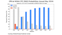
It is with high likelihood that ocean-atmosphere patterns will swiftly flip from El Niño to La Niña in the coming months, fostering an environment that is more conducive for storm development.
The release of this year’s seasonal outlook likely holds a little more appeal and is met with more curiosity in the wake of Colorado State’s aggressive forecast issued in early April.
At that time, CSU framed the season as “extremely active" with a call for 23 named storms, 11 hurricanes and 5 major hurricanes.
Viewed as the two pillars of tropical seasonal outlooks, NOAA and Colorado State have captured the pre-season limelight this year. But they’re not the only forecasts pointing at an above-average season.
Forecasts from private sector and academic institutions are calling for an active season as well, averaging 11 hurricanes for 2024.
The season officially begins June 1st and, at this time, there are no signs of life in the tropics. This is a good thing considering 12 storms have formed in the pre-season since 2012.
Again, one of the pillars for this season’s above-average number of storms will come from the transition away from El Niño, which is already occurring, to La Niña. This ocean-atmosphere phenomenon is tucked away in the equatorial waters of the Pacific Ocean and serves as a driving force for Atlantic basin activity.
El Niño tends to produce more upper-level wind shear, a deterrent to Atlantic storm formation. These seasons tend to average fewer storms.
However, 2023, an El Niño season, failed to show much restraint to storm development as 20 systems formed. This included Idalia, which made landfall in September as a category 3 hurricane in Florida’s Big Bend.
This year, La Niña is forecast (77% likelihood) to settle in and coincide with the peak of hurricane season. This is the alignment we don’t want, but it looks inevitable. La Niña, which features cooler water and the lack of rising air in the Pacific, lends itself to lighter winds in the Atlantic basin. These seasons feature less wind shear are likely to produce more storms in a less-hostile wind environment.
While the state of the atmosphere in the Atlantic Basin isn’t quite primed for activity, water temperatures prove ready as they failed to adequately cool in the off-season. At this time, sea-surface temperatures in mid-May are running closer to August levels and demonstrate an essential ingredient for storm formation in the coming months.
Brian McNoldy, a senior research associate at the University of Miami’s Rosenstiel School of Marine, Atmospheric and Earth Science has been keeping tabs on water temperatures across the Atlantic Basin.

His frequent posts to X continually advise that, both, sea surface temperatures and ocean heat content (OHC) have run far above average in the off season.
He was asked to frame up his view of the season ahead, and his response was not unexpected.
"We’ve never had water temperature anomalies like this. And when you combine that with what’s certain to be a La Niña, no one has seen this before," McNoldy said.
As a reminder, these forecasts attempt to capture the total number of storms in the Atlantic, Caribbean and Gulf of Mexico for the season. A reflection on how active, above or below, a season may be. However, there is no skill in predicting where systems develop or where they track.
Allow the seasonal forecasts to serve as a catalyst for your preparation plan this season and the necessity to monitor the tropics, especially mid-August to mid-October.
The NBC6 First Alert Weather team is making sure you’re prepared for hurricane season. Watch our special “Ahead of the Storm” – on NBC6 Friday, May 31 at 7:30pm. Additionally, it will stream on all our platforms as well.
Stop by for 2024’s updated NBC6 hurricane guide, coming soon to nbc6.com.
