
Isaías strengthened into a hurricane late Thursday night and the Bahamas are now under a Hurricane Warning.
A Tropical Storm Warning was in effect for the southeast Florida coast including Broward and Miami-Dade counties due to the chance for tropical storm conditions late Saturday and Saturday night.
Stay up to date with NBC 6 First Alert Weather and South Florida's most powerful radar First Alert Doppler 6000 by downloading the NBC 6 app for iOS or Android.
In other words, hurricane conditions are not expected, and tropical storm conditions are possible.
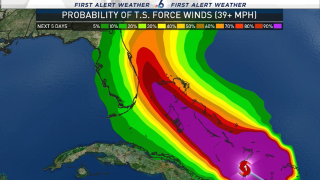
The National Weather Service provides an excellent graphic on their tropical webpage which graphically shows you the “reasonable worst-case scenario” for our area.
This is a scenario that has a 10% chance of occurring, as per the NWS definition. So, for example, if that reasonable worst-case scenario showed potential winds of 100+ miles per hour, I would be recommending that you be putting up or closing your storm shutters Friday or at the latest Saturday morning. Instead, it shows Miami’s worst-case for winds in the low-end of tropical storm force – 39 to 57 mph.
For Fort Lauderdale the worst-case is a high-end tropical storm wind of 58 to 73 mph. This helps you make an informed decision of “preparing for the worst and hoping for the best."
If you go to their page, you can click on your neighborhood, a window pops showing the actual forecast for Fort Lauderdale (as of 11 a.m.) of peak winds 30-40 mph gusting to 55 mph. But you can read on for the potential winds of 58 to 73 mph – the worst case. Winds of 30 to 40 mph is the condition Fort Lauderdale is likely to see. Winds of 58 to 73 mph is the condition Fort Lauderdale is very unlikely to experience, though not impossible.
There has been remarkable consistency in the U.S. GFS model in placing a hurricane north of the West End of Grand Bahama on Saturday evening over the last several runs.
The GFS ensemble has some members that bring a weaker tropical storm to make landfall in Florida, but all stronger solutions are for a hurricane to stay offshore. The same applies to the European ECMWF ensemble. Some of the 50 members of the ensemble show a tropical storm making landfall in Florida, but every track for a strong Isaías keeps the hurricane offshore.
Local


Right now the National Hurricane Center is forecasting a 90 MPH hurricane in the northwest Bahamas.
Bottom line: Hurricane Isaías’ intensity has remained steady-state since Thursday night and has now reached the southern Bahamas. It is moving northwest and forecast to start moving north-northwest then north this weekend. The turn is particularly likely if it remains a hurricane, even more so if it strengthens further.
If upper level wind shear weakens Isaías, then there’s a chance for a closer encounter with Florida. That is why there’s a Tropical Storm Warning in effect locally. There’s also a Hurricane Watch from Palm Beach County to Indian River County.
But the official forecast from NHC has Isaías passing 80 miles away from Miami on Saturday, placing the entire metro area in the weaker southwest side of the hurricane. Miami has a 30% chance of experiencing tropical storm force winds and a 1% chance of hurricane winds. Fort Lauderdale has a 56% chance of experiencing tropical storm force winds and a 5% chance of hurricane winds.
