
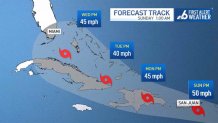
Tropical Depression Fred was moving along Cuba's northern coast and could regain tropical storm status as it pulls away from the island on Friday, ahead of its projected track towards the Florida Keys on Saturday and southwest Florida on Sunday, forecasters said.
Meanwhile, still east of the Caribbean Sea, forecasters were watching another tropical depression that they said would likely become Grace, the seventh named storm of the Atlantic hurricane season.
South Florida was in the initial cone of concern for Tropical Depression 7, which had maximum sustained winds of 35 mph but was expected to become a tropical storm Saturday.
Get South Florida local news, weather forecasts and entertainment stories to your inbox. Sign up for NBC South Florida newsletters.
A Tropical Storm Warning is in effect for Antigua and Barbuda, Anguilla, St. Kitts and Nevis, and Montserrat, Saba and Sint Eustatius, Sint Maarten, and St. Martin and St. Barthelemy. A Tropical Storm Watch is in effect for the British Virgin Islands, U.S. Virgin Islands and Puerto Rico.
Meanwhile, the Miami-based National Hurricane Center said Fred had maximum sustained winds of 35 mph and was dropping heavy rain over parts of Cuba, where the main threats were rain and flooding.
Fred was about 150 miles southeast of Key West and moving west at 12 mph, the NHC said.
Local

A tropical storm warning issued for the middle and upper Florida Keys and Florida Bay as well as a tropical storm watch for the west coast of Florida have been discontinued as of Friday night.
A tropical storm warning is still in effect for the Florida Keys west of the Seven Mile Bridge to the Dry Tortugas.
Forecasters said little change in strength was expected in the coming hours, though Fred could regain tropical storm status again on Saturday.
The hurricane center said 3 to 7 inches of rain were expected across the Florida Keys and southern peninsula by Monday, with isolated maximums of 10 inches.
No evacuations are planned for tourists or residents in Monroe County, Keys officials said Friday. The county’s emergency management officials are advising people in campgrounds, recreational vehicles, travel trailers, live-aboard vessels and mobile homes to seek shelter in a safe structure during the storm.
Winds between 35 and 40 miles per hour are possible as far north as Broward County through Saturday.
Residents can get sandbags Friday at three locations in Miami-Dade: at Grapeland Park (1550 NW 37th Avenue), Legion Park (6447 NE 7th Avenue) and Veterans Park (7600 NW 50th Street).
WATCH: Tropical Depression Fred Tracker
Once a tropical storm, Fred weakened back to a depression by its spin over Haiti and the Dominican Republic, where it knocked out power to some 400,000 customers and caused flooding that forced officials to shut down part of the country's aqueduct system, interrupting water service for hundreds of thousands of people. Local officials reported hundreds of people were evacuated and some buildings were damaged.
The system was expected to produce 3 to 5 inches of rain across the Dominican Republic and the western Bahamas, as well as 1 to 3 inches over Haiti, the Turks and Caicos, the eastern Bahamas, and Cuba.
Fred became the sixth named storm of the Atlantic hurricane season late Tuesday as it moved past the U.S. Virgin Islands and Puerto Rico.
