
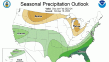
The National Oceanic and Atmospheric Administration's U.S. Winter Outlook for this year says the El Niño weather pattern is still active heading into the winter this year, meaning the northern and far west portions of the U.S. will have a warmer-than-usual winter, while western and southeastern swaths of the U.S. will have a wetter winter than usual.
The bottom line for us here in South Florida? We are looking at equal chances of seeing below or above-average temperatures from December through February. But it's a different story when it comes to precipitation: South Florida is looking at a 60-70% chance of above-average precipitation from December through February.
Seasonal forecasts, whether for winter or spring or for hurricane season, are rarely of any significant use in the world of day-to-day weather forecasting, and we tend to take these long-range forecasts with a grain of salt. They are non-precise and generalized for a very large area (the entire country) and for a long period of time (three months for winter, six months for hurricane season).


Get South Florida local news, weather forecasts and entertainment stories to your inbox. Sign up for NBC South Florida newsletters.
But the methodology behind the NOAA Seasonal Forecast is where things get interesting because we can look at the potential long-term weather patterns that can absolutely influence our day-to-day weather. This year, the main driver of the winter forecast is El Niño, something that in the past has affected the weather across the United States and even here in South Florida.
El Niño is a global climate pattern that tends to happen every few years. Sometimes it can be present for more than one consecutive season, and sometimes it disappears for seven years or more. Forecasters are very good at identifying it with high certainty as it's building in, but its local impacts have much lower confidence. Sometimes it leads to exactly what is expected and sometimes it does not.
With hurricanes, El Niño can change water temperatures and create wind shear, which can affect tropical development. In the winter, when it is most pronounced, it's about temperatures and precipitation patterns.
For South Florida, El Niño is all about the subtropical jetstream. This is the river of air that can take moisture from the Pacific Ocean and spread it across the lower forty-eight. Because El Niño tends to shift this jetstream south, it essentially moves from west to east from the Pacific Ocean across Mexico and the far-southern United States, which allows it to cross over Florida more frequently. This can lead to an increase in rain coverage throughout the winter, which is how NOAA came up with its wet winter forecast for South Florida.
As far as temperatures, El Niño has tended to lead to cooler-than-average winters in South Florida because the colder, Arctic air can dip south with the jetstream. In fact, the last time we had an El Niño as strong as the one we are forecasting this winter, 2009-2010, we had an exceptionally cold season.
But climate change may make that more difficult. With the planet and oceans warming, it's harder to get the colder temperatures to South Florida, and that's why NOAA is forecasting an average winter — not above normal and not below normal.
