
We are now ten days into what is known as “Meteorological Spring” and experiencing the warmest stretch of weather since October - but a fairly impressive cold front will push through on Saturday and bring some chilly weather Sunday morning and gorgeous weather Sunday afternoon.
Ahead of the front, temperatures and humidity will continue to climb. We have already set several warm temperature records Wednesday and Thursday mornings and with highs in the mid-80s Friday and closer to 90 degrees on Saturday, many more records will fall.
With the high humidity, feels-like temps could be in the mid-90s by Saturday afternoon.
Get South Florida local news, weather forecasts and entertainment stories to your inbox. Sign up for NBC South Florida newsletters.
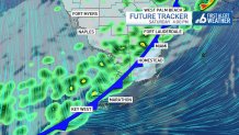
The cold front looks to push through late Saturday afternoon into the evening. This will allow temps to really pop on Saturday and actually keep most of the day dry. Rain chances will pick up after 3 p.m.
While the west coast of Florida could see some stronger storms, by the time the front gets here, we expect scattered showers and only a few isolated storms.
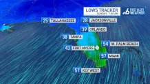
The drier air starts surging in Saturday night, but we will really feel the chillier weather by Sunday morning with lows in the 50s across all of South Florida with even some lower 50s away from the water.
Sunday afternoon will be delightful with highs in the mid-70s along with lots of sunshine.
Local


Looking at longer-range computer models, this may very well be our last chance at a cold front this season.
