
It’s the home stretch. Seventy percent of hurricane season is behind us as of Friday.
By several measures, the season has been quite active as compared to normal. There have been 18 tropical storms producing 87 named storm days, which is 55 percent above the normal to date. Accumulated Cyclone Energy (ACE), which accounts for storm longevity and intensity, is 28% above the normal to date. And we’ve already reached the average yearly allotment of three major hurricanes in a full season with Franklin, Idalia, and Lee.
On the other hand, the number of hurricanes so far in 2023 has been underwhelming given everything else that’s happened. Only one-third of the storms have reached hurricane status this season. Normally, half of the named systems are able to become hurricanes. Had the 2023 hurricanes to storms ratio remained on par with the norm, we should have already seen 9 hurricanes. Instead, there have been only 6.
The poster child for underachieving storms is now Tropical Storm Phillipe, which just concluded its two-week life cycle as a tropical system not far from Bermuda. The storm established a record for the longest-lasting continuous North Atlantic tropical cyclone to never intensify to hurricane intensity. Wind shear was ever-present over Phillipe, keeping it from strengthening despite the presence of very warm water in the Atlantic.
Get South Florida local news, weather forecasts and entertainment stories to your inbox. Sign up for NBC South Florida newsletters.
Those very warm sea surface temperatures, which remarkably have remained at record-hot levels every day for 7 straight months (!!), are the reason for the great number of Atlantic storms so far in 2023. But El Niño enhanced wind shear has been able to keep many storms from strengthening.
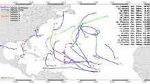
When you look at a map containing the tracks of all 2023 Atlantic storms, one thing jumps out: the storms have mostly turned out harmlessly to sea. The left or west side of the map, where North and Central America are, is pretty empty. Arlene, Harold, and Ophelia are on it, but those remained at tropical storm strength.
Local


Of course, Idalia is on that part of the map. It went through a remarkable rapid intensification phase in which it ramped up to major hurricane status before striking the Big Bend region of Florida. But because that part of the coastline is sparsely populated, damage, severe in some cases, was confined to a handful of small communities. And Lee was a scary category 5 hurricane that lost its tropical characteristics and weakened before impacting down east Maine and the Canadian maritime provinces.
The middle part of the map includes the eastern Caribbean. Tropical Storm Bret brought a modest early-season lashing to the Windward Islands. Then tropical storms Franklin and Phillipe produced floods on some islands in August and October, respectively.
The rest of the storm tracks, including all hurricanes except Idalia, were clustered in the middle portion of the open Atlantic Ocean where they didn’t impact anyone but marine interests. The reason for the benign tracks? The Bermuda High was weak this year thanks to a wavy jet stream and summer cold fronts dipping equatorward to deflect the hurricanes northbound.
While historically October can still be a busy month in the tropics, things this year are looking pretty quiet heading into the middle part of the month. The Cape Verde season’s last hurrah, in the form of a tropical wave off the coast of Africa, is expected to recurve prematurely. And in the areas favored for October development like the western Caribbean, Bahamas, and Gulf of Mexico, nothing is brewing right now.
We’ve managed to escape the worst up to now. But we should remain alert.
