
National Hurricane Center forecasters, as good as they are, are not known for bold predictions.
Their conservative approach has helped us keep calm and carry on with life-saving preparations even in the face of short-term swings in storm behavior and hurricane forecast guidance. Their forecast adjustments have historically been slow and steady.
Climate change is now forcing their hand.
JOHN MORALES ON HURRICANE SEASON

Get South Florida local news, weather forecasts and entertainment stories to your inbox. Sign up for NBC South Florida newsletters.
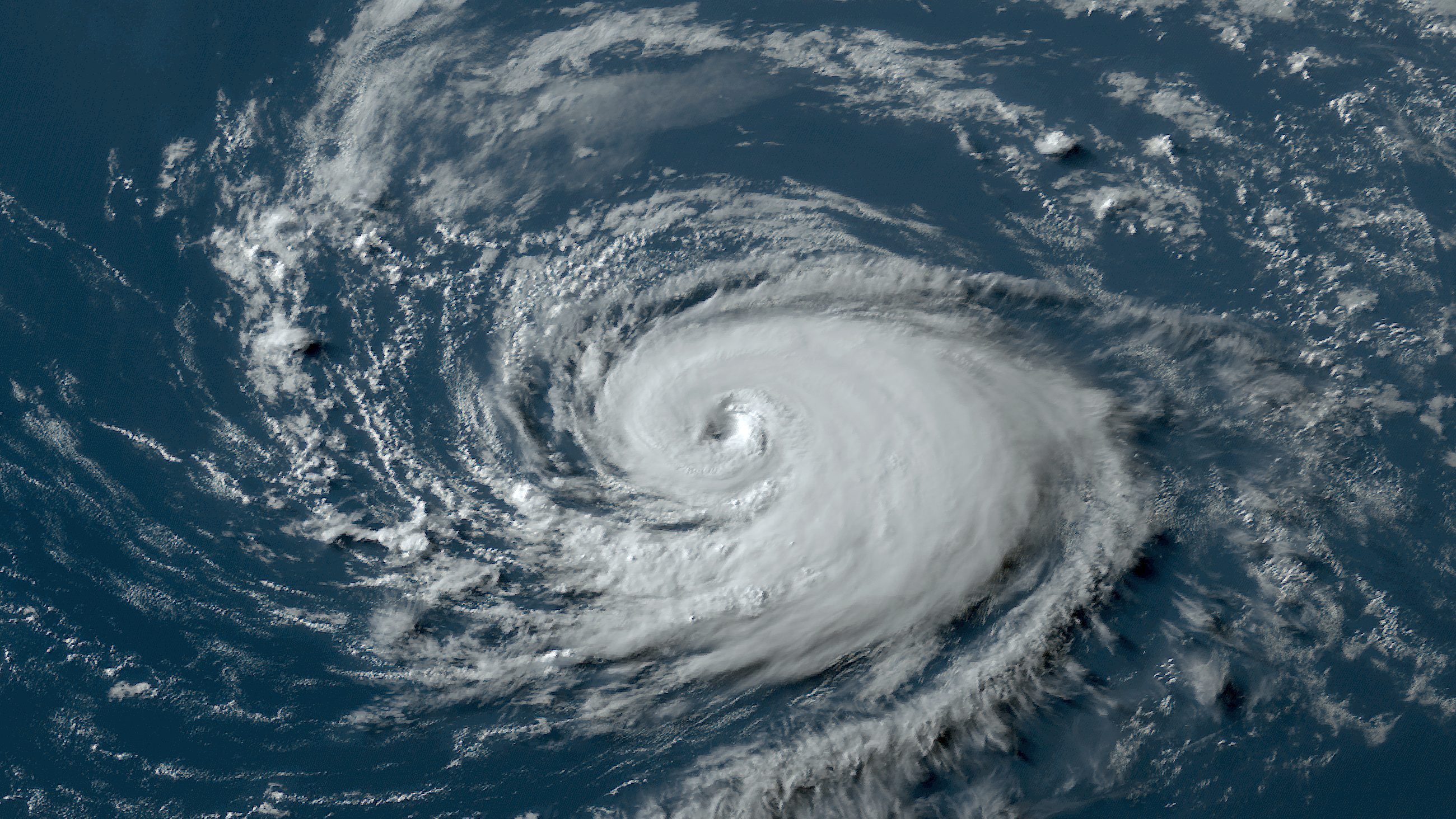
The very first forecast posted by NHC for Tropical Depression Thirteen, now Hurricane Lee, immediately called for a high-end category 4 hurricane. It is the record most aggressive initial intensity projection from NHC, going back at least to the year 2000.
And now on Thursday, the NHC is calling for Lee to become a 160-mph category 5 monster over the Atlantic this weekend.
Keep in mind, only 6% of hurricanes in the last 100 years have reached category 5 intensity. Explicitly calling for an extremely rare event in a forecast takes guts. But the Atlantic is so incredibly hot right now that, statistically, there’s only a 2-hundreths-of-1-percent chance (0.02%) of us observing such warmth.
The NHC forecasters see that too, and are more than justified in posting such an extreme and unusual intensity forecast for Hurricane Lee.
Watch live: Track Hurricane Lee as it moves across the Atlantic
In my many decades as a meteorologist specializing in tropical weather, I have noticed a marked uptick of forecasts in which NHC explicitly calls for a tropical system to undergo rapid intensification. That’s especially the case in recent years.
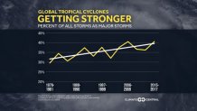
After all, peer reviewed research shows that the proportion of tropical storms becoming catastrophic category 4 and 5 hurricanes (or typhoons) is rising. It’s not that we’re seeing more tropical storms in general. Just that more of the ones that form are going through these rapid intensification cycles in which wind speeds increase at least 35 miles per hour in 24 hours.
And modern-day hurricanes sometimes go through downright unbelievable intensification, like Hurricane Jova just did Wednesday in the eastern Pacific. It saw an 85 mph jump in maximum windspeed in 24 hours, leading to another (previously) rare category 5 storm by Wednesday evening. It’s still out there as a Cat 4, thankfully not threatening land.
Will future potential Cat 5 Lee make landfall anywhere? Let’s hope not.
The Caribbean islands are going to miss the core of Hurricane Lee. According to the NHC forecast, the eye of the hurricane would miss the British Virgin Islands by 280 miles, Puerto Rico by 320 miles, and the Dominican Republic by 400 miles. Then it’s forecast to turn north thanks to a dip in the jet stream coming off the east coast of North America.
That would keep the nucleus of the dangerous major hurricane away from the Turks and Caicos and the eastern Bahamas. However, that north turn means that folks in Bermuda are concerned.
And residents of Canada’s easternmost provinces, and even New Englanders in the U.S., are aware of Lee and hoping that a northbound track will be followed by another turn to the northeast, sparing them.
Notice I haven’t even mentioned Florida because there is no reason to be concerned about Lee.
However, indirect effects from the powerful storm could start impacting island states in the west Atlantic as early as Friday. High swells will generate hazardous marine and beach weather. Distant outer rainbands could yield strong downpours and modest gusty winds this weekend.
Any of us would take the indirect effects of a Cat 5 instead of a direct landfall, obviously, every day and twice on Sundays. Lee will make its closest approach to the Caribbean this Sunday.
John Morales is NBC6's hurricane specialist.
