
The much anticipated Atlantic hurricane season awakening is here. Or is it?
You already know about the remarkably slow start to the 2022 season. Only three tropical storms have formed so far, the last one dissipating way back on July 3rd.
Normally by this date, based on the 1991-2020 average, a half-dozen storms should have already been named with two of those reaching hurricane status. In 2022, we haven’t even seen a whisper of a system approaching hurricane strength.
Two measures are particularly striking in terms of hurricane inactivity in 2022: we've had three "named storm days" versus a normal of 22 by this date — less than 15% of normal.
Get South Florida local news, weather forecasts and entertainment stories to your inbox. Sign up for NBC South Florida newsletters.
Using the more technical Accumulated Cyclone Energy (ACE) index, which tracks storm longevity and strength, we’re running a remarkable 91% below normal so far this year!
Forecasters, including myself, have been warning that the first two-and-a-half months of the season may mean nothing in terms of how peak season will behave. But we are now just two weeks away from that peak of September 10, and still no new tropical storms have formed.
The Atlantic basin did show signs of life this weekend. The American GFS global forecast model latched on to a Caribbean disturbance, insisting that it would become a hurricane down the road in the Gulf of Mexico.
Given the state of that disturbance, that outcome seems doubtful.
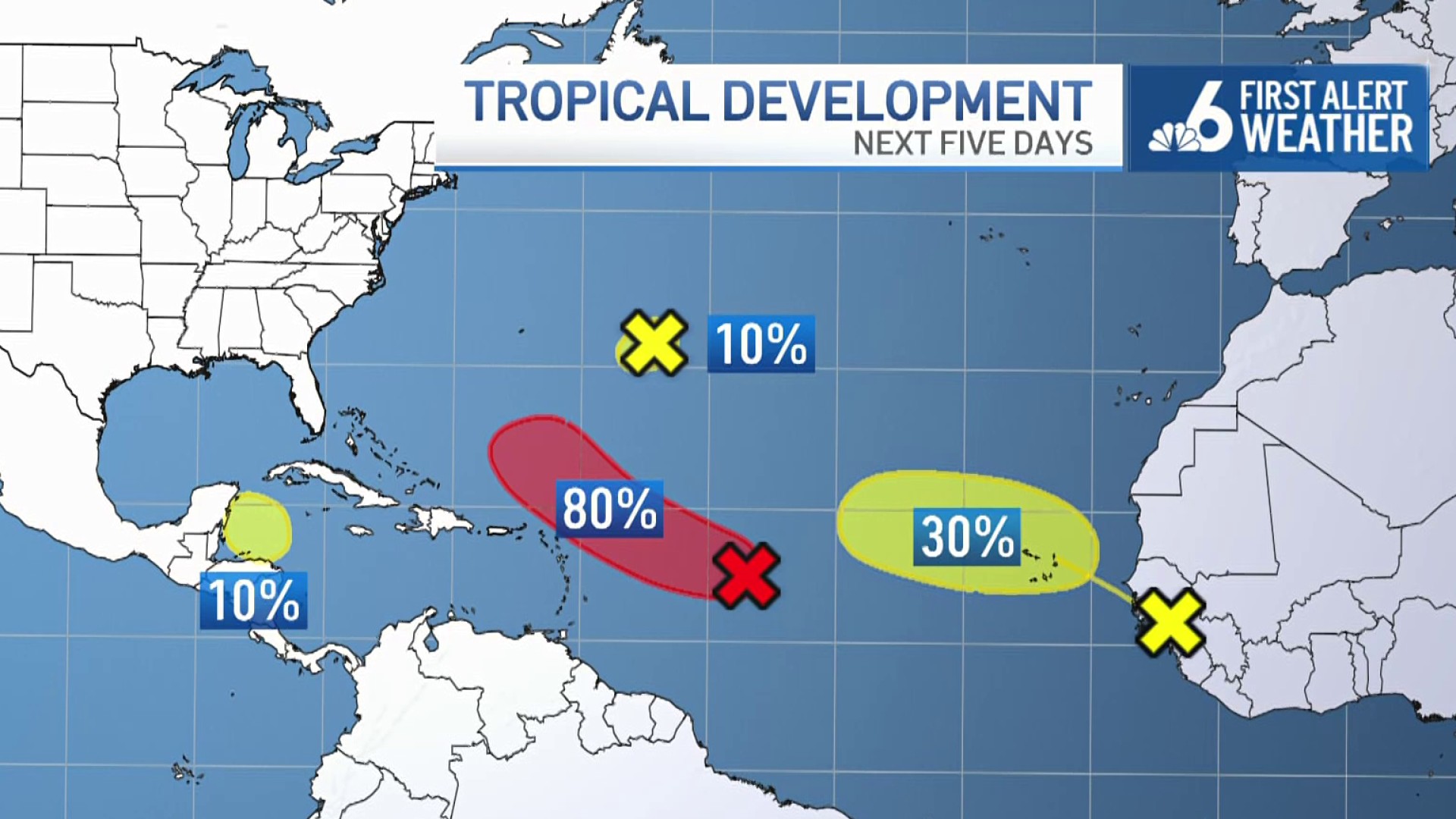
There’s also been a tiny system near Bermuda with a small chance of development, as well as a tropical wave just coming off the west coast of Africa which might have a shot at forming down the road while remaining far out in the eastern Atlantic.
Of greater interest is a sprawling area of disorganized showers and thunderstorms about midway between Africa and the Lesser Antilles—currently labeled Invest 91L, which both the GFS and the European global models see as a potential future tropical storm. It’s got dry and dusty air ahead of it as well as unfavorable upper level wind shear which could worsen as it aims towards the Atlantic waters north Puerto Rico.
But with the two most trusted global models developing it into something, the National Hurricane Center on Monday listed its chances of doing so at 80%.
With 91L still so disorganized and facing marginal if not hostile atmospheric conditions, I still think we’ve got a chance to go 0-for-August. In other words, a super-surprising August named-storms shutout in a year that was forecast by all seasonal prognosticators to be hyperactive.
If Invest 91L does finally develop, the long-term track forecast beyond early next week (when it’s expected to be over the open ocean east of the Bahamas) is still uncertain. Like with all September systems, it’s in everyone’s best interest to continue to monitor it. But for now, 91L poses no imminent threat to South Florida.
We still need to get through the Atlantic’s peak hurricane month of September, and then Florida’s peak hurricane month of October, before we can write 2022 off. Keep your hurricane emergency plan handy, just in case, while keeping fingers and toes crossed.
John Morales is NBC 6's hurricane specialist.
