
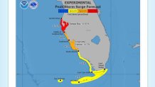
Rapidly strengthening Hurricane Ian will impact Cuba on Monday night and emerge into the Gulf of Mexico on Tuesday on a now high confidence forecast track that keeps the eye of the tropical cyclone well away from South Florida.
The wind field in the system has expanded, so parts of the Florida Keys were placed under a Tropical Storm Warning. Miami and Fort Lauderdale were expected to remain at no less than a 200 mile distance from Ian’s center, and it appears unlikely that we will see that type of alert for our region.
That’s not to say that there won’t be momentary strong gusts in the rain squalls that are expected to plague our area starting as early as late Monday, continuing Tuesday and Wednesday, and possibly even Thursday.
Get South Florida local news, weather forecasts and entertainment stories to your inbox. Sign up for NBC South Florida newsletters.
The showers will be strong enough to trigger flooding in some neighborhoods, with widespread accumulations in excess of 3 inches and the possibility of up to 8 inches of rain before it's all said and done. Isolated tornadoes cannot be ruled out starting Tuesday.
How will Hurricane Ian impact other parts of Florida?
Unfortunately for the rest of the state, the forecast is much worse.
Ian has officially undergone rapid intensification, with winds increasing 35 mph in a span of 18 hours between Sunday night and midday Monday. This process is likely to continue thanks to a deep pool of very warm water surrounding Cuba on all sides and extending into the Gulf region west of the Florida Keys.
HURRICANE IAN LATEST

Upper level winds are still ideal for strengthening too, though that will change late this week when a dip in the jet stream starts impinging upon Ian with wind shear that could weaken the hurricane.
It is becoming increasingly clear that no matter where Hurricane Ian makes landfall in Florida, the west coast of the Sunshine State is staring at a big water disaster in the making.
A Category 3 or 4 system approaching on a northeast track would drive enormous amounts of Gulf water eastward and produce a storm surge as deep as 10 feet above ground for communities on the shores of Tampa Bay. With Ian expected to slow down considerably, the surging seas could be in place for several tide cycles in the middle of King Tide season, when the highest tides of the year happen.
Add to that a foot of rain that has nowhere to drain because of the encroaching Gulf of Mexico, and the flooding will be exacerbated.
What can Florida expect from Hurricane Ian's winds?
A forecast for 130 mph winds is certainly an attention grabber, and if any community ends up facing those it would obviously be catastrophic. But even as confidence grows on Hurricane Ian’s eventual path, it is nearly impossible to forecast which towns will see those given the geography of the Florida peninsula and the oblique angle of approach from Ian.
The chances for hurricane force winds were increasing all along Florida’s Gulf coast, from Naples and Fort Myers in the south to Tallahassee and Apalachicola in the north.
For Miami, that chance was less than 1%.
John Morales is NBC 6's hurricane specialist.
