
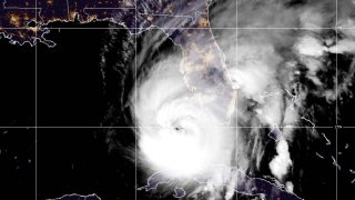
Hurricane Ian was already a major and potentially catastrophic storm. And then it grew into a behemoth on Tuesday.
After pounding the western province of Pinar del Rio and knocking out power to the entire country of Cuba, Ian emerged into the Gulf of Mexico on Tuesday morning. As it moved north, radar and satellite images started to show a new and larger eye forming outside of the compact eye that had crossed western Cuba just a few hours earlier.
Ian underwent an eyewall replacement cycle.
This process happens naturally, usually in stronger hurricanes, when a larger wall of thunderstorms starts to surround and choke off the inner core of the hurricane’s original and smaller eye. Gradually, the new ring of thunderstorms surrounds the older concentric eyewall, which eventually disappears.
Get South Florida local news, weather forecasts and entertainment stories to your inbox. Sign up for NBC South Florida newsletters.
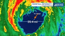
The resulting new eye of the hurricane can be much larger, spreading destruction across a larger area. In Ian’s case, the original eye was 20 nautical miles in diameter. The new one was 75% wider — 35 nautical miles.
Hurricanes stop strengthening when they go through an eyewall replacement cycle. With this process having completed late on Tuesday evening, now Hurricane Ian may intensify further into a Category 5 hurricane before making landfall.
Technically, Ian made its first landfall on U.S. soil on Tuesday evening when the center moved directly over the Dry Tortugas, west of the Florida Keys. Fort Jefferson, inside Dry Tortugas National Park, experienced the calm of the eye and may have been able to peek at the stars while at the center of the hurricane.
Ian’s most impactful landfall will be coming up on Wednesday on the west coast of Florida.
With Tampa no longer the target, the track seemed to aim directly at the coasts of Sarasota, Charlotte, Lee and Collier counties. Some of the communities that may experience the strongest winds and most destructive storm surge included Venice, Punta Gorda, Port Charlotte, Cape Coral, Sanibel, Fort Myers and possibly even Naples.
The storm surge could be as high as 12 feet above ground in the most low-lying coastal communities. The wind could be sustained at 130 miles per hour (mph). Twenty-four inches of rain might accumulate. And tornadoes are likely.
Hurricane Ian


It’s a gigantic disaster in the making for Florida’s west and southwest coast, and for agricultural and frontline communities like Arcadia, Immokalee, LaBelle, and Okeechobee.
For South Florida and the Keys, impacts were varied. Tornadoes produced damage in parts of Broward County, but wind gusts outside of the tornadoes were modest. In contrast, Key West had hurricane-force wind gusts of up to 76 mph and Marathon reached 58 mph. Over a half a foot of rain produced flash flooding in both Miami-Dade and Broward counties.
Rain and tropical storm force gusts to around 50 mph can be expected on Wednesday in South Florida’s metropolitan area, but winds will be decreasing quickly in the Florida Keys as Ian moves away. New episodes of heavy rain could produce new bouts of flooding. The tornado threat, thankfully, will be trending down.
By Thursday, Ian will be moving into northern Florida and drier air will start to filter into the southern end of Florida. Winds will drop off. While thunderstorms are still possible, the rain is not expected to be as long-lasting or widespread. On Friday, the entire state will see clearing skies as Ian loses strength in Georgia and the Carolinas.
